Define Your Business Goals
The very first step you will need to take is to define your business and goals of using point cloud software. For example, if you focus on data collection, and your responsibilities end when you hand over point cloud data to your customers. Your primary concern would be to select the best point cloud software that facilitates efficient and accurate data collection processes, and includes robust registration tools to align and merge multiple scans or images to create a comprehensive and coherent point cloud dataset.
Should your business helps to convert point cloud data into CAD documentation: 2D drawings, topographic plans, 3D or BIM models and deliver it to architects, engineers, civil engineers, constructors, BIM managers, cultural heritage specialists, designers, or manufacturing companies, so that they can save a lot of time in doing it themselves. You will require an efficient and accurate solution for converting point clouds into CAD deliverables.
If your business provides a wide range of services, from data collection to converting point clouds into the documentation your customers need, you will need relevant software to both generate a point cloud and accomplish point cloud modeling tasks.
Data Capture & Point Cloud Generation
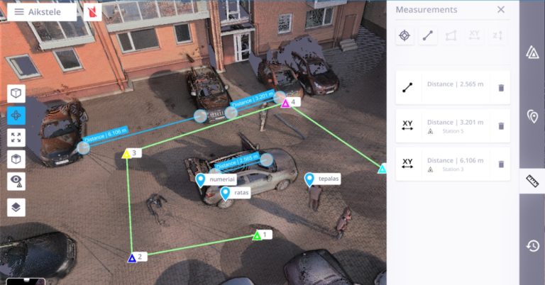
If your business focuses on data capture and point cloud generation, the first thing you need to think about is what hardware you use or will use.This is because the hardware you use will directly impact the quality, accuracy, and efficiency of your data collection process. It may sound boring, but in our nearly two decades of experience in reality captures projects, the best software to generate and process a point cloud comes from the same manufacturer as your chosen hardware. For example, Trimble scanner data will be easiest to process with Tribmle Realworks software, and Leica scanner data will be easiest to process with Leica Cyclone REGISTER 360 software, and so on.
However, more options are available when it comes to generating point clouds using photogrammetric software. These include; RealityCapture, Agisoft Metashape, PIX4Dmapper, 3DF ZEPHYR, DroneDeploy, and Visual SFM. 7, *.PTX, *.LAS, *.LAZ, *.PTS, *.PLY, and custom ASCII / TXT file format imports. Nowadays, all reality capture solutions allow point clouds to be delivered in universal formats that are compatible with any CAD application: *.E5
Producing 2D & 3D Deliverables
If your company specializes in converting point cloud data into 2D & 3D deliverables. Your focus should be on selecting point cloud software that specializes in point cloud to CAD conversion. The software should have robust tools for accurately and efficiently extracting relevant information from the point cloud and converting it into CAD-compatible formats like DWG, RVT, IFC, SKP, and PDF.
For 2D deliverables: Make sure the CAD software you pick has accurate measuring tools, layer management, and annotation features so you can produce accurate and thorough 2D representations based on the point cloud data.
For 3D modeling: To build intricate and accurate 3D models based on the point cloud data, the software should enable features like surface modeling, solid modeling, and meshing.
For BIM integration: Consider point cloud software that integrates with Building Information Modeling (BIM) platforms like Revit. By doing this, you can transform point cloud data into BIM models, enabling your clients to use BIM in design, building, and facility management processes.
Compatibility and Dedicated Point Cloud Modeling Tools
When choosing the best software for your point cloud modelling projects, pay attention to compatibility and dedicated point cloud modeling tools. Compatibility is very important because you are producing documents that will be used by AEC professionals (who typically use well-known software such as AutoCAD, Revit, SketchUp, and ARES Commander) for further design and development. You must therefore pay attention to whether the project you are delivering will be compatible with your customer’s software.
Another important factor when choosing software solutions to convert point clouds into 2D and 3D models is specialized tools that allow you to:
- Work with large and complex point clouds efficiently and accurately.
- Extract objects from point clouds to create 2D drawings, and 3D models faster.
- Slice your point cloud and easily control the information you see in your model view.
- Compare your 3D model and 2D drawings to the point cloud to check accuracy and identify missed details with live point cloud visualization.
In our opinion, for point cloud conversions, it is best to use the same software that your clients use. Our Undet team works with the following popular CAD programs: AutoCAD, Revit, SketchUp and ARES Commander. Even if these applications themselves support the import of point-cloud data, converting them into the required output using the built-in tools alone is complex and imprecise. That’s why we’ve developed an Undet plug-in for each of these, allowing you to take advantage of the tools on each CAD platform, speeding up the modeling processes.
Converting Point Clouds into DWG, RVT/IFC and SKP Models
DWG drawings: If your goal is to convert point clouds into DWG drawings, two ideal software choices are AutoCAD and ARES Commander with the Undet plug-in. These solutions offer seamless integration and provide efficient and accurate results for producing 3D models and 2D drawings based on 3D laser scan data. Both solutions provide flexibility in customizing the generated DWG drawings to meet specific project requirements. You can easily adjust layers, line weights, and other drawing elements, ensuring consistency with your organization’s standards and preferences.
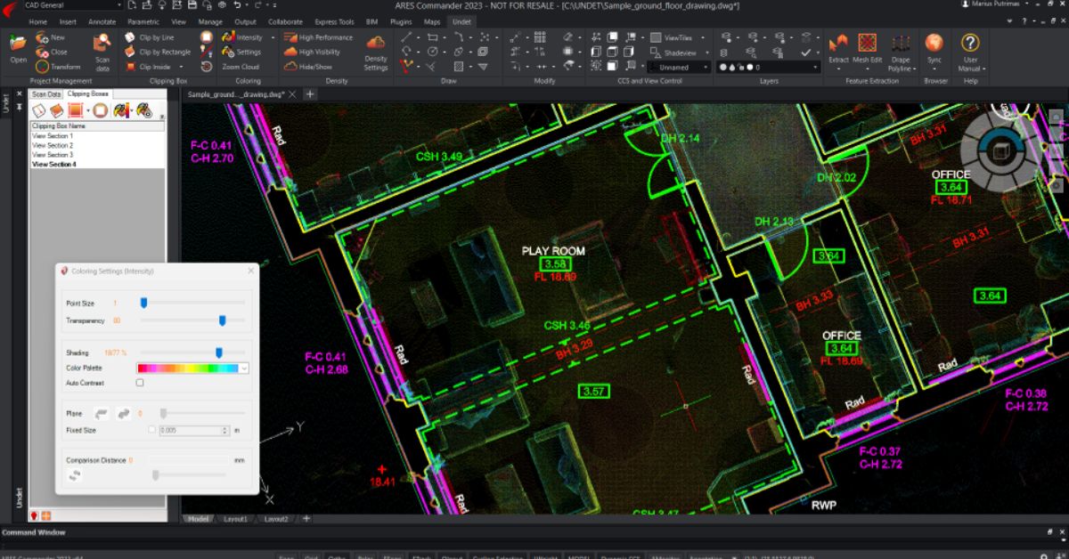
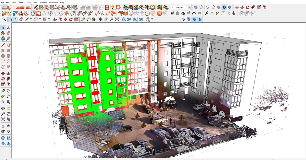
2D as-built documentation from Point Clouds. Point Cloud modelign software: ARES Commander + Undet.
RVT / IFC models: If your focus is on point cloud conversion work for BIM models, the Revit platform is the ideal choice. Revit is a powerful Building Information Modeling (BIM) software widely used in the architecture, engineering, and construction industries. This platform has the disadvantage that there are not enough specialised tools for point cloud processing. However, this can easily be solved with the Undet for Revit plugin. Users of Revit can expect a simple and effective process thanks to the intuitive tools and user-friendly interface the Undet plugin offers. The plugin makes the process of utilizing point clouds more efficient by streamlining activities like regulating visibility, cropping point clouds, and performance optimization.
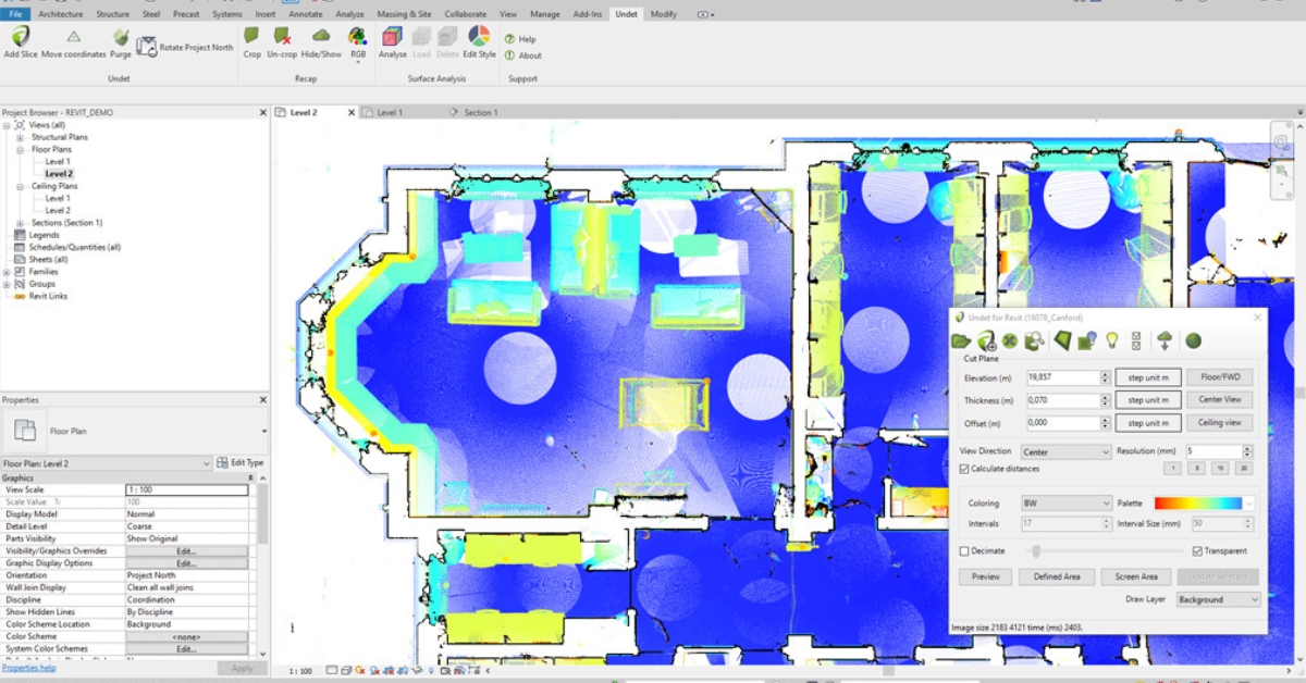
Point Cloud modeling software: Revit+ Undet.
SKP models: If your focus is on point cloud conversion work for 3D modeling in SketchUp, the Undet plugin provides the ideal solution. SketchUp is a popular software for creating 3D models, but it lacks specialized tools for point cloud processing. This is where the Undet for SketchUp plugin comes in to bridge the gap. With the Undet plugin, SketchUp users can seamlessly integrate point cloud data into their models and enjoy a simplified and efficient process.
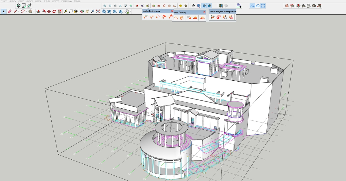
Point Cloud modeling software: SketchUp + Undet.
Undet Point Cloud Software
If you use AutoCAD, Revit, SketchUp, or ARES Commander, then it is well worth considering Undet. Our specialized point cloud plug-ins add an extensive range of features and capabilities to support your point cloud modeling projects and help your business realize its full potential when using reality capture data.
You can learn more about Undet for AutoCAD, Revit, SketchUp, or ARESCommander by clicking on the relevant links. You can also begin a free trial today for whichever plug-in is best for you. This is not a watered-down trial, you will have full access to the software just like if you had just bought a full license. Plus, we’ll set up a tutorial call to help get you started and walk you through our extensive collection of helpful articles and how-to videos.
Start your free trial today!