Undet Point Cloud to CAD solution

Specialized software suite to produce 2D drawings from scan data

Request free trial Buy Undet

Turn Point Cloud into 2D Drawings Quickly and Easily

Point cloud to CAD conversion is a daily task for many 3D laser scanning service providers. If you’re in need of software that enhances point cloud performance and offers cost-effectiveness, exploring this suite for generating precise 2D drawings, including elevations, floor plans, and sections, all derived from 3D laser scan data, could be highly beneficial.

SOFTWARE SUITE+
By combining the powerful Undet plug-in tools with ARES Commander CAD simplicity, we offer you an intuitive workflow to create 2D drawings based on precise as-built point cloud data quickly and easily.
Point Cloud plugin
Undet Point Cloud plugin for Ares Commander
This video is focusing on essential features of the Undet Point Cloud Plugin for ARES Commander. Undet lets you import and handle point cloud data directly inside the ARES Commander from any 3D laser scanner or drone mapping system.
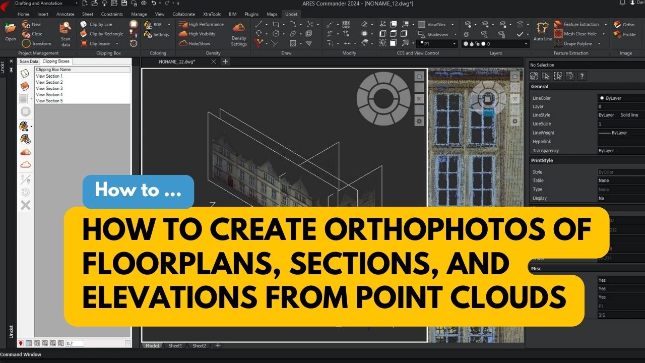
Specialized Tools for Floor Plan creation
This video is focusing on the advanced features to speed up the creation of accurate as-builts floor plans based on 3D point clouds. In the Undet plugin, you will find built-in and ready-to-use templates, dynamic blocks, and specialized workspace.
Specialized Tools to Annotate Floor Plan Drawing using Undet Browser
This video is focusing on specialized features to speed up and improve floor plan annotation workflow using Undet tools including unique features of Undet Browser.
2D & 3D CAD Software
How the User Interface of ARES Commander compares with AutoCAD?
Watch the video to understand how ARES Commander is offering an easy switch. AutoCAD users can instantly start using ARES Commander without any training.
Comparing fundamental CAD features of ARES Commander vs AutoCAD
This video is focusing on the comparison for the fundamental CAD features that are used by 80% of the users
Printing, Sheet Sets and PDF Import/Export using ARES Commander CAD Software
This video is focusing on the advanced features for printing and PDF, proving that ARES is making no compromises and even going one step further for PDF import.
  • Extremely quick and easy point cloud slicing with slice volume adjustment tools.

  • A dedicated Undet workspace to maximize focus on digitizing floor plans, divided into workflow phases: preparation, section view, floor view and ceiling view.

  • Specialized scripts to insert dynamic blocks of windows, doors, openings and recesses, and pilasters with few mouse clicks. 

  • Dynamic height level blocks to annotate drawings without taking extra measurements or editing attributes manually.

  • Undet Browser scripts to automatically create height annotation blocks by clicking on 360-degree panoramic images: door heights, beam heights, room heights and floor levels at once, floors to windows sill – sill to windows head heights and many more.

  • Auto-Multi line tool for fast 2D linework extraction with a single click to achieve best-fitting accuracy to actual point cloud slice.

  • Automatic view & UCS orientation tools: by line, by point cloud clip & by plane/objects. 

  • Polyline aligned tool to draw perpendicular lines instant from selected reference line.

  • Automated tools to group scan files into logical groups: external scans and internal level scans.

  • Orthophoto creation tools to quickly convert point cloud into raster images.

  • Automatic view sync feature to orientate view from the nearest scan stations in Undet Browser to unclear view of point cloud slice with a single click.

  • Quick access to point cloud viewer to view and analyze your 3D reality data in a way that feels like being live on site.

  • Point cloud colouring rendering mode by reference plane in fixed intervals to quickly understand changes in geometry to draw or identify missing lines/objects. 

  • Profile section image generation tools on plan view without changing the drawing plane and without rotating the view projection.

  • Model inspection colouring mode to check 3D model accuracy and identify missed details with real-time point cloud visualization while modelling.

  • Model Inspection QC Report generation tools to compare 3D model against point cloud and view report in Undet browser based on 360-degree scan station images. 

  • 3D Orbit rotation tools by selecting the rotation center point from point clouds. 

  • Smart snapping mode to snap to point cloud points in different ways (to the nearest, highest, and lowest points) and dismiss snapping error to noise points.

  • 100% DWG. ARES Commander is using the latest DWG file format, without any import or export. Read and modify drawings created with AutoCAD® (or other similar programs) and save directly in the same format. This includes any version of DWG from the very first ones to the latest versions of DWG.

  • Point cloud import from any laser scanner or drone: *.E57, *.FLS, *.RCP/RCS, *.PTX, *.ZFS,*.LAS, *.LAZ, *.PTS, *.PLY, *.DP, *.FPR, *.LSPROJ, *.FWS, *.CL3, *.CLR, *.RSP, ASCII / NEZ (X,Y,Z/i/RGB) and custom ASCII / TXT file format import.

  • Point cloud visualization with multiple colour modes: by source (RGB), by intensity, by plane, by Z (height), by scan stations, and by additional transparency mode.

  • Software is optimized to maintain high computer and software performance even when working with large amounts of point cloud datasets (hundreds or even thousands of scan stations/files).

  • Intuitive point cloud viewer integration to understand & see better what the point cloud represents. 

  • Coordinate system manager to move your point cloud quickly and align scan data to the UCS or move it to optimized coordinates to avoid screen glitching when working with georeferenced point clouds.

  • A dedicated toolbox for point cloud view sections management: activate, deactivate, delete, rename or export as a new Undet project.

  • Toggling tools of scan stations/files/view sections in no time, with an intelligent indicator to quickly identify the densest scan file in the active view section.

Ready to try?

Simply download Undet with ARES Commander and start reaping the benefits!

Turn point cloud into 2D drawings quickly and easily

License options

Software Suite+
1050
2590
Excluding VAT
Undet plug-in
700
1890
Excluding VAT
Undet's blog
 image
Undet for Revit
New Features Update

New Tools in Undet for Revit Plugin for Efficient Point Cloud Modeling   We’re thrilled to share new features and…

READ MORE
 image
Undet's practical applications
Modeling Architectural Elements

Modeling Architectural Elements from Point Clouds in SketchUp with UNDET Tools   In the fields of architecture and construction, 3D…

READ MORE
 image
Undet's practical applications
Ortophotos from Point Clouds

Orthophotos are images that show the true dimensions of objects, which can be used to accurately measure distances, areas, and…

READ MORE