Point Cloud Basics for Beginners

Your questions answered

Point cloud technology is becoming an increasingly important tool in the architecture and construction industries. Whereas just a decade or so ago, you needed highly trained experts to survey and create accurate 3D models of objects, this can now be done in a fraction of the time, and with considerably less training thanks to technological and software advances.

Today, for example, it is possible to use a laser scanner to scan building and have a precise digital 3D representation of it all within the same day, something that would have perhaps taken a week or more using traditional techniques just two decades ago.

It is not just the fact that building scans can be made quicker and more cost-efficiently that makes this technology so appealing. These scans can even be completed in buildings full of people, as well as in older and more delicate structures. Big leaps have also been made on the software front, which enable this scanned data to be turned into accurate 3D models in CAD software quickly and easily. 

At Undet, we have been a part of this transformation. Starting as a laser scanning company more than 15 years ago. Developing Undet point cloud software because none of the available software on the market was able to do what we needed. Today, we create point cloud software in the form of plugins that help professionals turn point cloud data into deliverables in AutoCAD, Revit, SketchUp and Ares Commander

In this article, we will answer some of the most commonly asked questions about one of the most important parts of this process – the point cloud. Including what it is, what it is used for, what technology is used to create point clouds, and how point clouds are used to create 3D models in CAD software?


What is a point cloud?


A point cloud is essentially a simple 3D model that is created from thousands (or sometimes millions) of individual measurements (known as points) of an object. Each of these points containing X, Y, Z, and orientation values, as well sometimes colour and intensity measurements.


How are point clouds created?


Point clouds are created by either LiDAR laser scanning equipment or by using high-resolution RGB cameras through a technique known as photogrammetry.

Using either technique, the X, Y and Z coordinate positions of a particular point can be calculated. When combined with thousands of other individually measured points, a simple 3D model of the surveyed object becomes visible. The fewer points that are measured, the simpler the point cloud representation will be, and the more, the increasingly detailed it becomes. 


point cloud data resulotion and details

This image shows the resolution and detail it is possible to obtain with 3D laser scanners. Capturing the entire environment down to the most minor details

point clouds quality difference, low and high quality

The image shows the quality difference when only a terrestrial laser scanner is used compared to a terrestrial laser scanner and a drone using the photogrammetry technique.

How do you create a point cloud?


To create a point cloud you will need to follow these 2 steps:

  1. Scan the object you want to create a point cloud for using LiDAR or photogrammetry devices.
  2. Use the specialized software that comes with each piece of hardware to process raw data into a 3d point cloud.

After that you can import this point cloud into CAD software such as  AutoCAD, Revit, Sketchup or Ares Commander, where (with the help of plugins like Undet) you can transform your point cloud into 3D models and 2D deliverables.


What are point clouds used for?


Point clouds are used to create accurate virtual 3D representations of objects (from historic monuments to modern skyscrapers). Because they can be created for the inside as well as outside of an object, the possible applications of point clouds are varied.

Take the example of historic monuments, perhaps the original blueprints of the building no longer exist or later changes have not been properly recorded. By using laser scanning technology or photogrammetry a point cloud of the building can be created, from which an accurate 3D model or 2D plans of the building can be created. 

Another application of the technology is to compare the accuracy of the building documentation that already exists to reality. This can be used in a variety of ways. For example, renovation works, if they begin based on original plans that are even just a few millimeters out, this could lead to potentially costly reworks. 

At the same time, when it comes to new construction, point clouds can be used to make sure that construction is going as planned. Another benefit is that precise documentation of the building can be created at each stage of the construction or renovation.


What is a point cloud model?


As mentioned above, a point cloud is essentially a simple 3D model which is made up of millions or billions of little dots (known as points), each point being a separate data measurement of a wall, door, staircase, window, etc. However, this is quite far from being a complete model that can be delivered to clients or used in a construction project. This is why it is more commonly known as just a point cloud rather than a model, because it is the basis from which proper 3D models and 2D deliverables can be made. 

point cloud process


What is point cloud data?


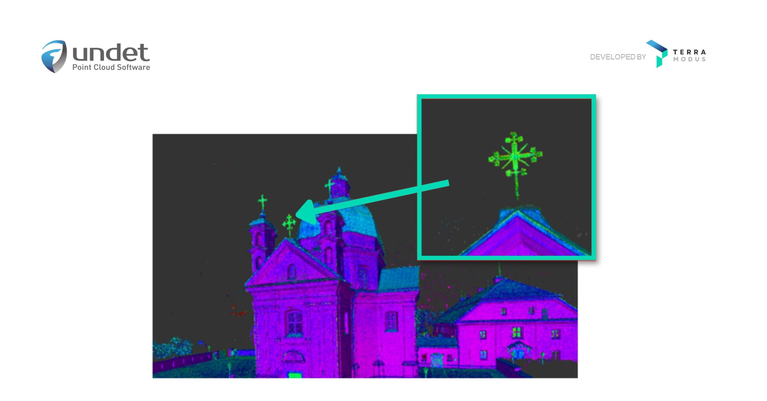
Point cloud data is very simply the data collected via LiDAR or Photogrammetry techniques. 3D point clouds are made up of millions (or sometimes billions) of individual points (hence the name point cloud). Each point containing its X, Y, and Z values along with its orientation (up or down). Some 3D scanners also record colour, which it saves as an RGB value, as well as intensity.


How is point cloud data processed?


Once you have collected your point cloud scan data via LiDAR or photogrammetry, there is still quite a bit of work to do in order to turn it into a finished 3D model that you can send to your clients. This is where point cloud processing comes in. 

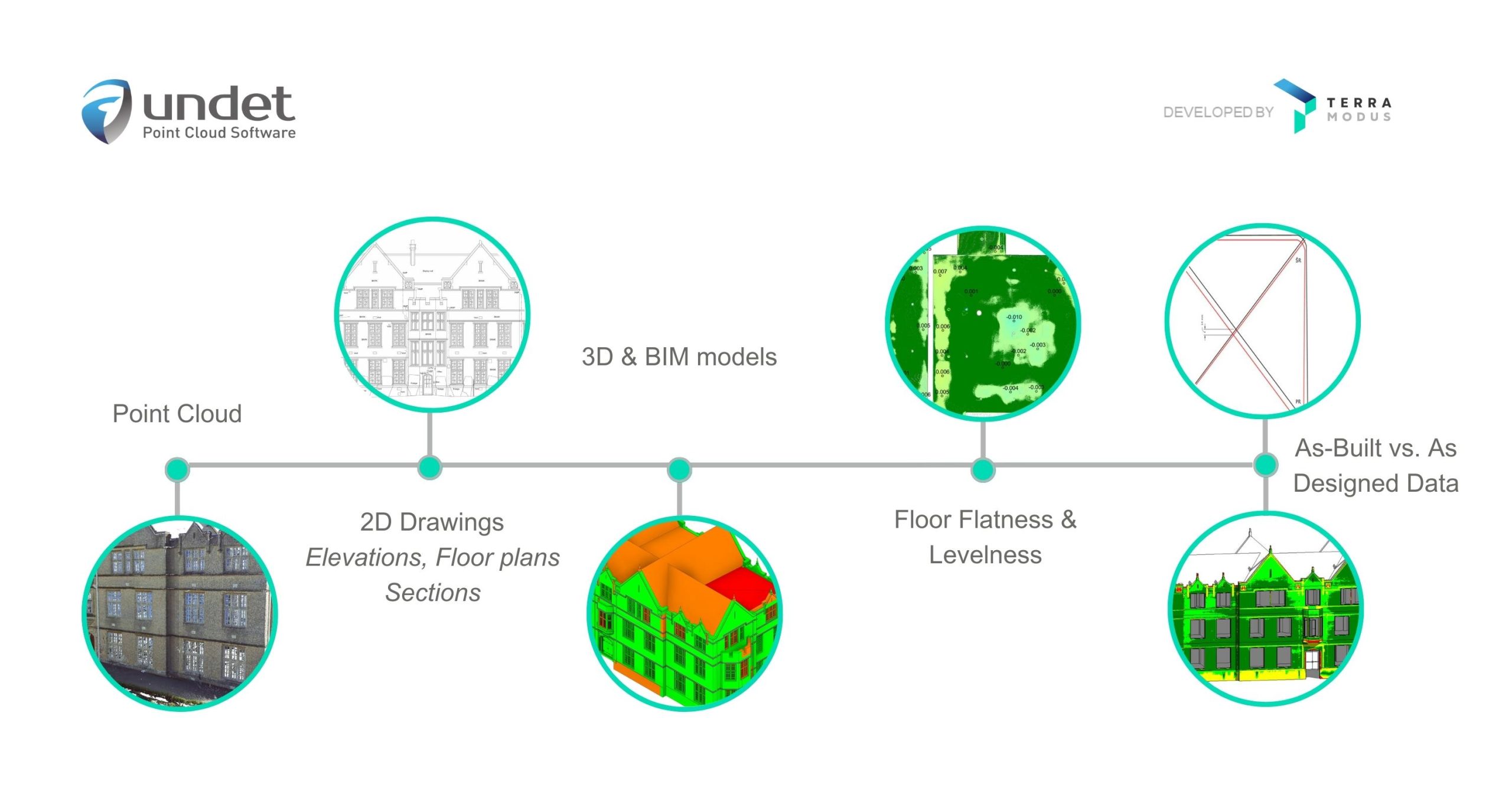
Using point cloud software such as Undet, you are able to import and work on this data in CAD software such as AutoCAD, Revit, SketchUp or Ares Commander. The software helping you to process your point cloud and turn it into your desired result, be it a 3D model, 2D plans or BIM deliverables. 

Essentially point cloud data is processed by the software based on what it is you want. For example, you may have scanned an entire building, but for the particular project you are working on, you only require data on the roof.  Point cloud software allows you to take out and work with only the data points you need. Allowing you, in this case, to accurately see, measure and model the current roof – and use that information to create a 3D model for a new roof or detailed 2D plans for renovations or documentation purposes.


What is point cloud software?


Point cloud software is software that helps you to import and work with point cloud data. Point cloud software, such as Undet usually comes in the form of plugins and extensions that are used in CAD software such as AutoCAD, Revit, ARES Commander and SketchUp.


How to choose the right point cloud software for you?


Because both free and paid point cloud software is available, it therefore comes down to your specific requirements and how much you can afford to spend. As you might expect, paid software often has much more functionality and is more optimized for working with point cloud data than free alternatives. 


What additional features does point cloud software provide?


Point cloud software provides additional features and functionality that is specially tailored to working with points cloud data sets. As a simple example, point cloud software such as Undet, makes importing point cloud data much quicker, meaning you can get to work on your new project more quickly.

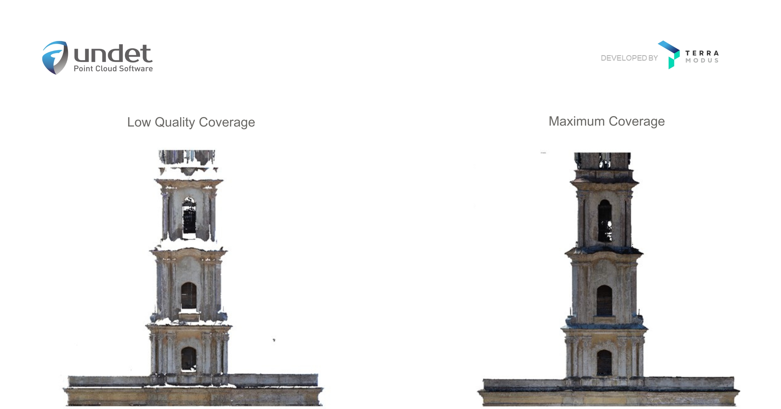
In addition, point cloud software generally offers a suite of other tools that make working with point clouds, meshes and 3D models easier and quicker. Some point cloud plugins and extensions also have tools that help you to check the accuracy of work. These quality assurance tools, potentially saving you a lot of time and money on costly reworks.


What can you do with point clouds?


Point clouds allow us to digitize an existing object, and make accurate 3D models or 2D drawings from it. This has applications throughout the entire life cycle or a building, from design, through to construction, renovation and operation.  

3 potential applications of point clouds are:

  • To carry out assessments and measurements when expanding or upgrading facilities and infrastructure.
  • To design and present your ideas and see how they will fit and affect an existing environment.
  • To document and archive the existing structure before changing or demolishing it.

Very simply, before we can change, rebuild or renovate something, we must assess and measure the current situation – this is exactly what point clouds allow us to do.


What is the difference between a point cloud and a mesh?


The basic difference between a mesh and a point cloud is that a mesh is a collection of interconnected triangles or polygons that come together to make a solid 3D surface, while a point cloud is a 3D representation made up of thousands or millions of dots (the points).

Meshes are used because they provide an efficient and lightweight way to represent complex 3D shapes. They can also be easily manipulated and textured in point cloud software. On the contrary, point clouds are usually less efficient when it comes to processing and rendering because they require more computational resources to represent a 3D shape accurately. To put this into some perspective, mesh models can reduce the size of point cloud files by as much as 90%. Making meshes much quicker to work with and easier to share with colleagues. 

This is why point clouds are often converted into a 3D mesh, which can then be used in CAD software to create 3D models, 2D plans and BIM deliverables.


What is the difference between LiDAR and Photogrammetry?


The difference between Lidar and Photogrammetry is basically the way in which each creates a point cloud and what technology it uses to do so. Whereas laser scanners use LiDAR technology, photogrammetry uses photos taken by high-definition cameras to deliver a similar result. But, to understand these differences in more detail and discover which option is best for you, we must first learn a little each. 


What is LiDAR?


LiDAR, which stands for “Light Detection And Ranging”, is a technology that uses lasers to build up a 3D image of an object or area being scanned. It does this by sending out pulses of light and measuring how long it takes for these to return and how strong they are. Each individual measurement coming together with thousands or millions of others to create a 3D point cloud. The use of lasers in this technology is also why you will commonly hear the term laser scanning a lot in this industry. 


What is Photogrammetry?


Photogrammetry uses photographs taken by high-resolution RGB cameras to create a 3D image of an area or object. This is possible because the photos are taken deliberately to overlap with one another and from various different vantage points in such a way that a 3D image can be generated from the 2D photographs. 


LiDAR or Photogrammetry: Which is best for you?


This is an important question. If you want the most accurate point cloud laser scanning measurements and results possible then opt for LiDAR. However, photogrammetry offers photo-realistic results, and costs less.

Point cloud modeling is essentially the process of taking a point cloud and creating a 3D model based on that data. Point cloud modeling is done in CAD software such as AutoCAD, Revit, ARES Commander or SketchUp, often using point cloud plugins such as Undet, which provide specific tools that make working with point clouds and creating 3D models much quicker and easier.

There are a number of benefits to using point clouds in the construction industry, including increased accuracy and better quality results than traditional techniques, easier sharing and collaboration options, as well as specific tools especially tailored to construction professionals

Undet’s plugins for AutoCAD, Revit, SketchUp and ARES Commander help improve your point cloud workflows by making it faster and easier to import, understand, and work on point clouds. That’s not all, our point cloud software provides a suite of specialist tools such as our inspection tools that let you compare building plans to scan data, which will save you time and money, as well as reduce the need for costly reworks. 

Put very simply, LiDAR is a technology that can be used to create point clouds. However, it is not the only method available, point clouds can also be generated using a technique known as photogrammetry.

Blog