1. Accurate As-built Documentation for all phases of construction
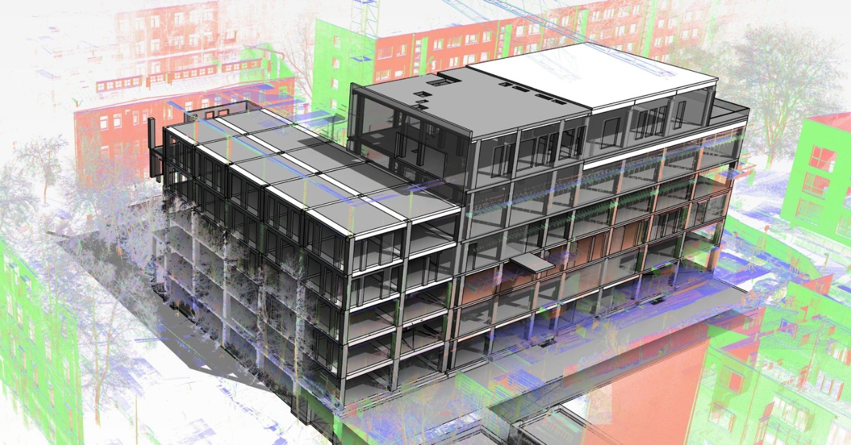
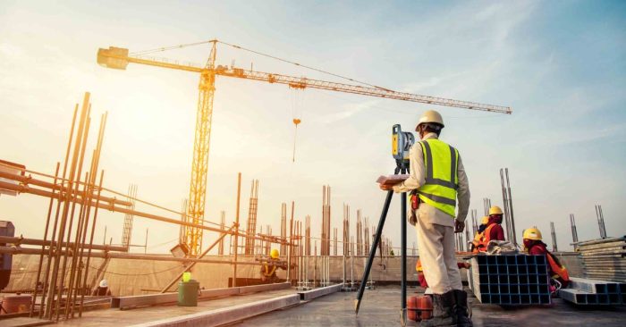
Reality capture devices, such as laser scanners or photogrammetry systems capture point cloud data, which can be used to create accurate and detailed documentation of existing structures or building sites. These precise digital representations providing accurate as-built documentation that can be used at each of the following stages of construction:
- Pre-Construction Phase: In the pre-construction phase, accurate as-built documentation forms the basis for the project. High-density point cloud data of existing structures or construction sites gives a precise picture of the location’s topography, structures, utilities, and infrastructure. Designers, engineers, and architects can then use this knowledge to create plans that perfectly fit the actual circumstances, minimizing design conflicts and guaranteeing the project’s viability.
- Design and Planning Phase: In order to make sure that the suggested design fits the actual environment, the design and planning phase significantly relies on accurate as-built documentation. Building Information Modeling (BIM) software integrates with point clouds produced by reality capture hardware to produce precise 3D models. Construction professionals can then more easily see problems, make wise decisions, and optimize the design to fit perfectly.
- Construction Phase: During the construction phase, precise as-built documentation is still essential. To compare the as-built circumstances with the design models, construction teams can collect point cloud data at various stages of the project. By doing so, any deviations or conflicts can be discovered early, guaranteeing that the building process follows the intended design. The early detection of construction mistakes makes it possible to correct them quickly, reducing costly reworks, and ensuring project standards are followed.
- Post-Construction Phase: The value of precise as-built documentation continues long after construction has finished. Collecting a full point cloud of the completed project acts as an accurate record of the current conditions, making it easier to maintain the facility, manage it, and make changes in the future. The precise documentation can be used by facility managers and owners to comprehend the structure, simplify maintenance tasks, identify specific parts, and monitor any alterations made during construction – ensuring the continued and sustainable use of the structure.
2. Perfect integration with BIM
Building information modeling (BIM), which offers a dynamic and collaborative approach to project management, has completely changed the construction sector. BIM allows teams to create dynamic 3D models, capturing all the physical and functional aspects of a project from planning and design all the way through to building and operation.
Point clouds are a key part of this process because they form the basis from which these dynamic 3D BIM models are made, and from which various members of a team can find and work on the data they need to conduct their specific jobs.
Converting point clouds into BIM models also means that all members of a team can have access to the model in real-time, meaning for example, that one person could be working on the roof of the structure at the office while another is modeling the piping from home.
And, because laser scanning and photogrammetry techniques are cheaper as well as more accurate than conventional techniques, scans can be conducted at regular intervals throughout a project’s lifecycle to check the accuracy of works and make adjustments accordingly.
3. Streamlined Retrofitting and Renovation:
Retrofitting and renovation projects present unique challenges in the construction industry due to missing or inaccurate building documentation. The former is especially an issue when it comes to historic buildings. In such buildings, it is also common for changes to have been made in the past which were poorly documented or not documented at all. By using laser scanners or photogrammetry techniques you can not only produce accurate 3D models, but also 2D plans, which can then be used as a basis for renovation works.
Where building documentation does exist, there is also the potential problem that it may not be entirely accurate, particularly if it has been taken using manual measurements or from original building plans. Commencing work based on such documentation can lead to headaches, delays, and increased costs if the documentation does not match reality.
4. Enhanced Collaboration, Communication, Visualization, & Verification
Reality capture technology is making it easier to collaborate and communicate with staff and stakeholders throughout the entire project timeline – from planning through to construction and completion.
The main reason for this being the digital nature of point cloud data, meaning that it can be easily shared online, enabling easy collaboration for teams in different locations (potentially anywhere on the globe). In addition, CAD software and immersive virtual reality (VR) technology make it possible to transform point cloud data into completed projects in the form of 3D models that can be shared and experienced by stakeholders and end users.
With the help of this immersive technology, it is also easier for construction professionals to visualize spatial relationships, spot design flaws early, and communicate project information to clients, financiers, and construction crews.
At the same time, point clouds make it possible to compare a model’s as-designed state with the actual state of the build. Providing accurate construction verification, which helps construction teams to spot discrepancies or deviations early by superimposing the design model over the point cloud data, minimizing reworks and ensuring that the project proceeds as planned.
5. Save Time and Money
Using point clouds will help you to save both time and money in the following 4 ways:
- Reduced errors and reworks – As a result of laser scanners and photogrammetry techniques providing accurate 3D point clouds of any scanned structure or object. This greatly reduces the chances of errors in data collection compared to conventional techniques. When you add that point cloud software such as Undet includes specialist QA and QC features potential issues can also be flagged and addressed before costly reworks.
- Better timelines – Point cloud technology saves time at almost every stage of the project lifecycle. From faster data collection, to processing and project completion. Because point cloud data is more accurate the chance of errors that lead to delays or reworks is also greatly reduced.
- Better project outcomes – It is not just the fact that point cloud technology makes it possible to deliver construction projects more quickly and with less issues or reworks that creates better project outcomes. The accurate 3D models created can be shared with clients and stakeholders, keeping them up to date with developments, providing a better customer experience.
- Cost savings – The old adage of “time is money” is true. Reading the three points above as well as the rest of the article has shown countless ways in which using point clouds will save you time, and hence money. However, in addition, having accurate data will also allow you to more accurately assess the costs of materials required (something especially important at the moment with soaring inflation), and reduce waste.
How Undet’s point cloud software will improve your construction projects?
Undet’s point cloud plug-ins for AutoCAD, Revit, SketchUp or ARES Commander offer several useful features and capabilities that will make working on your construction projects easier and quicker, including:
Accurate As-Built Documentation: Undet software enables the creation of precise as-built documentation by processing and analyzing point cloud data captured from your construction site. This documentation provides a realistic representation of existing conditions, allowing your project team to have accurate as-built 3D models, BIM models, and 2D documentation (plans, elevations, sections).
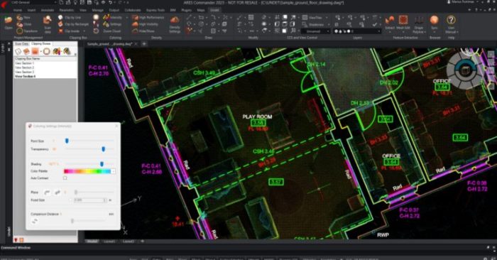
From Point Cloud to 2D drawings. Software: ARES Commander + Undet
Design Verification and Clash Detection: With Undet point cloud software you can compare as-built conditions with design plans. By overlaying the point cloud data onto the design model, you can identify any discrepancies, clashes, or deviations from the original plans. This will help you to detect and resolve potential issues early in the construction process, minimizing costly reworks and ensuring accuracy.
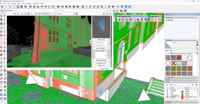
Design Verification and Clash Detection. Software: SketchUp + Undet
Visualization and Communication: You can easily view reports generated by comparing as-built point clouds with the design model thanks to Undet Browser’s advanced visualization capabilities. Improving stakeholder, client, and team understanding of the site, design intent, and construction progress.
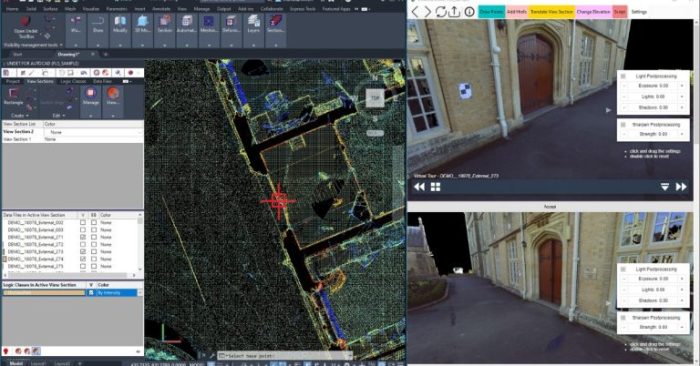
Laser scanning data vizualization with Undet Browser (Point cloud viewer)
Start reaping the benefits of using point clouds in your construction projects today thanks to Undet’s specialist point cloud plug-ins for AutoCAD, Revit, SketchUp and ARES Commander. Sign up for your free trial today. This is not a watered-down trial, you will have full access to the software just like if you had just bought a license. That’s not all, we will also schedule a tutorial call to help get you started and also show you are large knowledge base full of helpful articles and how-to videos.
 To put it briefly, using point clouds will enable you to complete your construction projects more quickly and accurately, improving timelines and reducing costs. This is possible thanks to